
2016 was a great year for us, It was full of excitements and learnings. We started the year with our public beta and within 3 months we went live. We received some really helpful feedback from our users which help us in a big way and we would like to thank everyone for that.
All these appreciation and love motivates us to go further with our products. And now we are proudly announcing that with start of this year we manage to come with our all new product - Marine Distance Table.
Introduction
Many of our user asked us to create sea distance matrix for them, which requires some manual works and causes some time delay in the process. Then we decided to automate the whole process so that anyone can get distance matrices without any delays. That’s how Marine Distance Table comes into picture.
What purpose Marine Distance Table solves:
Cargo and vessel operators need to plan their voyage, which is very crucial part of overall operation. They need sea distances from one point to another at one place fast and easy to calculate their cost and time. Aquaplot distance table provide unlimited sea distance between any two points in fastest, easiest and most cost effective way .
What Marine Distance Table is:
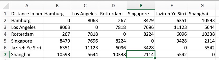
Marine distance table provides a matrix of distances between a large number of points in downloadable format. Unique part of this table that user will get distance between any two points - not only recognized ports. Users have full flexibility to chose any coordinates on sea and to choose any number of points.
How to get distances with help of Marine Distance Table:
User can get sea distances in downloadable format in just 4 simple steps
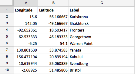
- Upload a file containing all coordinates (Longitude, Latitude, Label - see below).
- System will validate file’s format and coordinates.
- After validation system will suggest the exact price.
- After payment, system will start processing your file and you will get download link within 24 hours with all the calculated distances.
We are hopeful that this new product will help cargo operators to plan their operations in cost effective manner. In meanwhile keep us sending your feedback and queries.
From Aquaplot with ♥
(background image courtesy Marcel Sala)